Project Background
Bangkok is a rapidly expanding city with a high population density. The government has established development guidelines for the city and its surrounding provinces, namely Phra Nakhon Si Ayutthaya, Chachoengsao, Nakhon Pathom, Samut Sakhon, Samut Songkhram, and Ratchaburi. The focus is on developing an integrated rail mass transit system to facilitate travel, promote the distribution of residential areas and employment centers, reduce transportation costs, lower energy consumption, and enhance the quality of life of the population. This approach is in line with the 20-Year National Strategy on Enhancing National Competitiveness.
The State Railway of Thailand (SRT) has implemented the Red Line suburban railway project, with some sections already in operation since 2021, while additional route extensions are currently under development. The Salaya–Nakhon Pathom suburban railway project is a key extension intended to connect the transport system in Bangkok and its metropolitan area and to support the national railway network in line with the R-Map concept. Since the previous study, conducted in 2007, contains outdated information, the SRT is required to appoint a consultant to review the design and prepare new bidding documents so that they are consistent with the current environment and present needs, and to support the approval process for the subsequent construction project.

The Salaya–Nakhon Pathom suburban rail project integrated with long-distance rail services for connecting the mass transit system in Bangkok and its metropolitan area is an extension of the Red Line suburban railway project, Taling Chan–Salaya section, together with three additional stations: Rama VI Station, Bang Kruai–EGAT Station, and Ban Chimphli Station. It also forms part of the plan to develop a comprehensive railway network covering and linking areas nationwide and supporting seamless multimodal transport connectivity under the R-Map concept. In 2007, the Office of Transport and Traffic Policy and Planning (OTP) carried out the study and detailed design for the suburban rail system integrated with long-distance rail services to connect the mass transit network in Bangkok and its metropolitan area, covering the sections Rangsit–Ban Phachi Junction Station, Makkasan–Chachoengsao, Taling Chan–Nakhon Pathom, and Mahachai–Pak Tho. Therefore, in order to ensure that the rail mass transit network is developed in accordance with the development plan, the SRT is required to appoint a consultant to review the detailed design and prepare bidding documents for the Salaya–Nakhon Pathom section. This is intended to obtain updated study results that can be used to support the approval process for project construction. The original study prepared by OTP in 2007 reflects conditions from more than 15 years ago, and the surrounding environment has now changed significantly.
Project Objectives
SRT intends to engage a consultant to review the feasibility study results, conduct economic and financial analyses, prepare the construction cost estimate, carry out the detailed survey and design, draft the land expropriation decree, prepare the Environmental Impact Assessment (EIA) report, and draft the tender documents for the Salaya–Nakhon Pathom suburban rail project integrated with long-distance rail services to connect the mass transit system in Bangkok and its metropolitan area.
Expected Benefits of the Project
Upon completion of the project, people in Bangkok and its metropolitan area will benefit from a well-connected transport system that enables convenient, rapid, and safe travel, saves time, reduces energy consumption, lowers road pollution, promotes the economy of the surrounding provinces, and enhances the modernity and efficiency of the railway network.
Scope of Work
The consultant shall, at a minimum, carry out the following tasks:
Review the feasibility study results so that the study findings are up to date and can be used to support approval for the project construction. At a minimum, this shall include:
1.1) Reviewing the results of the study and detailed design of the suburban railway system integrated with long-distance rail services to connect the mass transit system in Bangkok and its metropolitan area, Taling Chan–Nakhon Pathom section, which was previously conducted by the OTP in 2007.
1.2) Studying and analyzing the implementation of related projects, including both completed studies and those currently under study.
1.3) Studying the train operation plan, taking into account the overall Red Line suburban railway system, and proposing the most appropriate operational pattern.
1.4) Reviewing government policies and infrastructure development plans related to transport, such as the 20-baht flat fare policy for electric rail services and the plan to develop a nationwide railway network with seamless multimodal connectivity (R-Map), etc.
1.5) Studying and verifying physical data, such as railway alignment levels, drainage data, and geological survey data.
1.6) Assessing the suitability of railway track layout, stations, stabling yards, maintenance depots, and related components, including railway crossings and station access/egress points.
1.7) Studying station accessibility, provision of facilities, safety systems, park-and-ride arrangements, station area development, and surrounding traffic systems.
1.8) Studying connectivity within a 500-metre radius of each railway station, together with Intermodal Transfer Facilities (ITF), such as public bus transfer points, taxi stands, pedestrian walkways, and park-and-ride buildings.
1.9) Studying travel connections between stations and surrounding communities, educational institutions, and major organizations within a 2-kilometre radius.
1.10) Studying feeder transport systems or secondary mass transit systems to connect passengers from key communities to the railway network.
1.11) Preparing the project feasibility study report, with the study and analysis topics presented in accordance with the requirements of the Office of the National Economic and Social Development Council (NESDC).
Conduct economic and financial analyses.
Prepare the construction cost estimate.
Carry out surveys and detailed design, including:
4.1) Surveying the project alignment and preparing topographic maps, land boundary maps, and utility maps.
4.2) Surveying structures requiring relocation, as well as encroachers within the SRT land required for project construction, and estimating relocation and compensation costs in accordance with relevant government regulations (if any).
4.3) Conducting geological and geotechnical investigations.
4.4) Surveying and inspecting catchment areas (canals, rivers, reservoirs, etc.), structures obstructing drainage, as well as bridges, culverts, and drainage systems along the route; analyzing and forecasting rainfall and flood conditions in order to assess the drainage capacity of bridges and culverts under the original construction design, and revising or redesigning them as appropriate for present and future conditions.
4.5) Surveying and inspecting railway-road intersections at existing at-grade crossings, and designing traffic management measures in construction areas to minimize impacts on road traffic during construction.
4.6) Coordinating with and obtaining approvals from relevant government agencies so that the detailed design complies with applicable requirements, rules, regulations, orders, standards, and relevant development or construction plans of those agencies.
4.7) Preparing the Detailed Design Criteria and Standards Report.
4.8) Preparing the detailed design in accordance with the railway structural standards of the Office of Transport and Traffic Policy and Planning (OTP), the railway design standards of the Department of Rail Transport (DRT), and international standards.
4.9) Designing the signalling and telecommunication systems, together with the Centralized Traffic Control (CTC) system, in accordance with SRT standards.
Prepare the draft royal decree for land expropriation.
Prepare the Environmental Impact Assessment (EIA) report.
Prepare the draft tender documents.
Prepare the Hazard/Risk Log report and any other necessary reports.
Prepare a study report on commercial area development and project facilities, establish the area development layout, and prepare the area development master plan.
Project Study Area
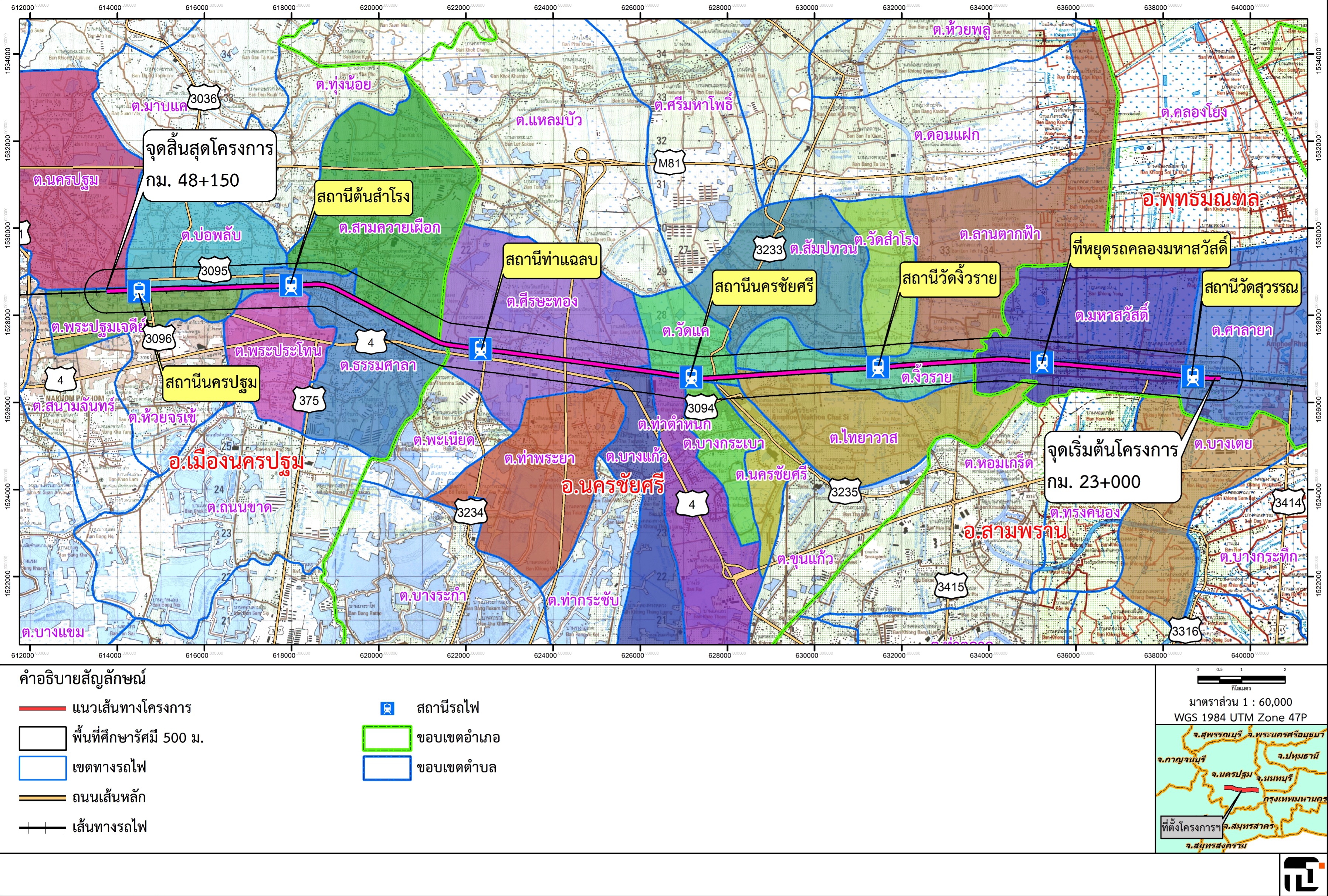
The study area covers a distance of 500 metres from the centreline of the project alignment, encompassing 21 Subdistricts in 4 Districts within 1 Province. These include 6 Subdistricts in Mueang Nakhon Pathom District, 12 Subdistricts in Nakhon Chai Si District, 2 Subdistricts in Phutthamonthon District, and 1 Subdistrict in Sam Phran District, as shown in the figure and table.

Project Details
Project Concept
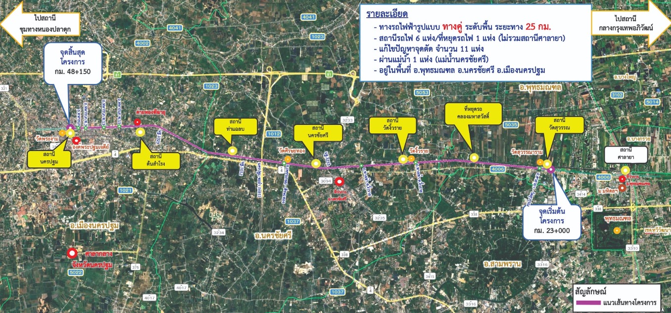
The preliminary concept for the railway alignment design of the project is to ensure integration with the SRT Red Line suburban railway project that has already been implemented. The project will commence at the end point of the Siriraj–Taling Chan–Salaya section, which is an at-grade track, at Km. 23+000, and will terminate at Nakhon Pathom Station at Km. 48+150, with a total distance of approximately 25 kilometres, as shown in the figure. The project will include 7 stations and halts, namely Wat Suwan Station, Khlong Maha Sawat Halt, Wat Ngio Rai Station, Nakhon Chai Si Station, Tha Chalaep Station, and Nakhon Pathom Station. The railway alignment design is based on the following key principles:
Performance and technical requirements: The design shall accommodate both the electric railway system and long-distance rail services, with an axle load of U20 and a maximum speed of 160 km/h, in accordance with SRT requirements and relevant design standards.
Seamless connectivity and intersection improvement: The design shall ensure seamless integration and address crossing points with other transport networks.
Minimization of social and environmental impacts: The design shall minimize land expropriation, relocation of utilities, and impacts on SRT assets, while also avoiding environmental impacts and complying with relevant rules and regulations.
Cost-effectiveness and operation: The design shall emphasize simple structural forms to reduce construction costs, while determining suitable locations for stations and the maintenance depot in line with operational and maintenance requirements.
The preliminary railway alignment design of the project is divided into two sections, as follows:
Wat Suwan Station–Ton Samrong Station Section
This section will be designed as a double-track railway at grade. To address the issue of at-grade railway-road crossings, the proposed solution is to construct four U-shape road overpasses crossing over the railway, as follows:
Salaya–Wat Suwan Road
responsible agency:
Department of Public Works and Town & Country Planning
Access road to Ngio Rai Subdistrict
responsible agency:
Ngio Rai Subdistrict Administrative Organization
Access road to Wat Ngio Rai
responsible agency:
Ngio Rai Subdistrict Administrative Organization
Phet Kasem–Sisa Thong Road
responsible agency:
Sisa Thong Subdistrict Administrative Organization
Ton Samrong Station–Nakhon Pathom Station Section
This section will be designed as a double-track elevated railway, as the area is a community zone with relatively heavy traffic. To resolve at-grade road crossings, the railway will be elevated to cross over four municipal roads in Nakhon Pathom Municipality, as follows:
Ton Samrong–Bo Phlap Road
(Thahan Bok Road Soi 15)
Huai Chorakhe–Wat Thung Noi Road
(Thahan Bok Road Soi 13)
Nakhon Pathom–Wat Klang Road
(Thahan Bok Road Soi 3)
Phet Kasem–Sisa Thong Road
(Thahan Bok Road)
As the railway must be elevated to resolve the above crossing issues, and due to site constraints, Nakhon Pathom Station will need to be designed with an elevated platform to accommodate the electric rail system. The design will also take into account connectivity and the potential impact on the current passenger services of the long-distance rail system.
Environmental Impact Assessment
For the EIA of the Salaya–Nakhon Pathom suburban rail project integrated with long-distance rail services to connect the mass transit system in Bangkok and its metropolitan area, the study area extends along the project route for a total distance of approximately 25 kilometres.
It covers an area of 500 metres on both sides from the centreline of the project alignment, or more where it is considered that the impacts may extend beyond this boundary. In the case of archaeological and historical resources, the study area covers 500 metres on each side of the alignment. Overall, the study area covers 21 Subdistricts in 4 Districts within 1 Province, namely 6 Subdistricts in Mueang Nakhon Pathom District, 12 Subdistricts in Nakhon Chai Si District, 2 Subdistricts in Phutthamonthon District, and 1 Subdistrict in Sam Phran District.
Study Scope
The EIA for the project has been conducted with the objective of studying, analyzing, and assessing the environmental impacts expected to arise from project implementation during both the construction phase and the operation phase, in accordance with the Guidelines for the Preparation of Environmental Impact Assessment Reports for Land Transportation Projects issued by the Office of Natural Resources and Environmental Policy and Planning (ONEP), as follows:
1. Physical Environmental Resources
- Topography
- Geology and earthquakes
- Soil resources
- Meteorology and air quality
- Noise
- Vibration
- Hydrology / surface water
2. Biological Environmental Resources
- Terrestrial ecology
- Forest resources
- Wildlife resources
- Aquatic ecology
3. Human Use Values
- Land use
- Transportation
- Public utilities and public services
- Drainage and flood control
- Agriculture
4. Quality of Life Values
- Socio-economics
- Relocation and expropriation
- Community severance
- Public health
- Occupational health and safety
- Sanitation
- Aesthetics and tourism
- Archaeological sites, antiquities, and historically important places
Study Procedures and Methodology
The EIA is a detailed environmental study covering both positive and negative impacts during the pre-construction, construction, and operation phases. Its purpose is to establish environmental impact prevention and mitigation measures, as well as environmental monitoring measures, to be used as conditions for the engineering design and construction process, or to be incorporated as part of the construction contract for the contractor’s implementation. The environmental study procedure is illustrated in the figure.

Existing Environmental Baseline Study
Review and compilation of secondary data: Secondary data on various environmental resources within the project area, along the entire project alignment, and in adjacent areas shall be collected from documents, reports, maps, plans, and computer network databases of relevant agencies and organizations.
Field survey: Field investigations shall be conducted to collect data and undertake a detailed analysis of key environmental issues based on appropriate academic principles and methodologies. This shall include the identification of sampling locations, duration, frequency, timing of sampling, sampling and analytical methods, criteria and indices, as well as measurement methods, as presented in the table of indices and methods for monitoring key environmental factors.
table of indices and methods for monitoring key environmental factors

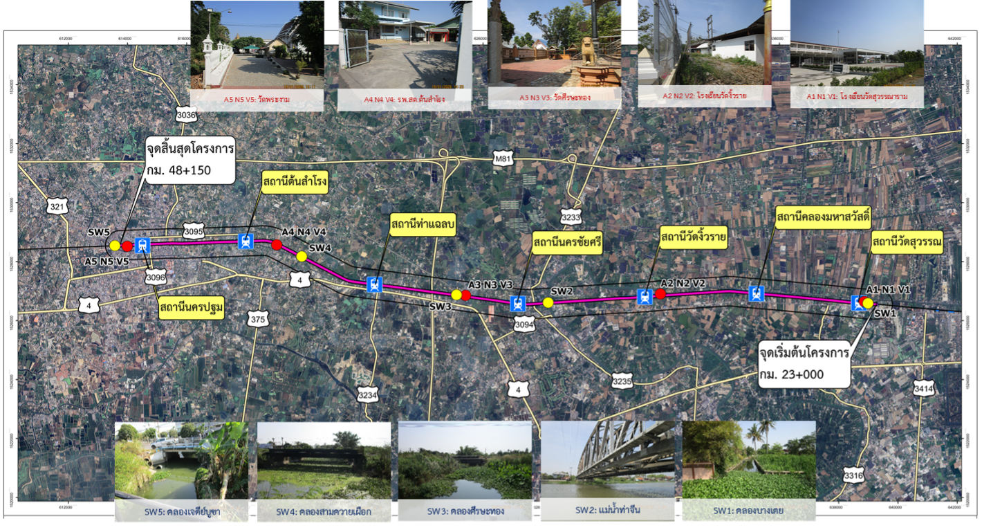
Air quality, noise, and vibration sampling stations.
Public Participation and Public Communication

The implementation of public participation and public communication activities for the Salaya–Nakhon Pathom suburban rail project integrated with long-distance rail services to connect the mass transit system in Bangkok and its metropolitan area is an important process for providing the public with accurate and comprehensive information about the project and for building a proper understanding of its details. It also serves to provide an opportunity for people in the project area and adjacent areas to participate in exchanging opinions, particularly those who may be affected, so that their needs can be reflected, concerns can be reduced, and their comments can be taken into account in project development. This is intended to ensure that the project is aligned with public needs, minimizes social and environmental impacts, gains public acceptance, and contributes to the successful development of the project. The project has been undertaken in accordance with the Prime Minister’s Office Regulation on Public Consultation B.E. 2548 (2005) and the ONEP Guidelines on Public Participation in the Environmental Impact Assessment Report Preparation Process, August 2023 edition, as illustrated in the figure.
Project Implementation Plan
Based on the activities required to be completed within
450 Days
from the commencement date, the Consultant has prepared a summary of the overall scope of work, as shown in the figure, together with the project implementation plan in accordance with the project timeframe and the interrelationship among the various activities.
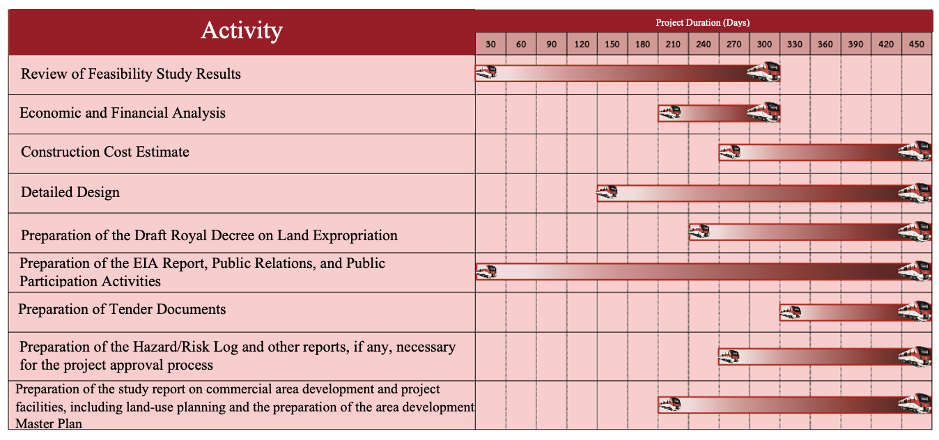

The project implementation plan indicates that the consultancy services for the feasibility study and detailed design are expected to be completed by 2027. Construction is scheduled to commence in 2029, with an estimated construction period of approximately 3.5-4.0 years, and the project is expected to begin operation in 2033.